
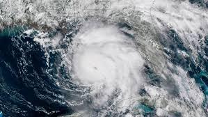
New Orleans is breathing easier as Tropical Storm Barry did not cause as much flooding and damage as predicted just a few days ago. However the city and the rest of the region is not yet out of the woods as hurricane season, which runs from June 1 to November 30, promises to be active this year. As authorities prepare for the next storm – because the only certainty is that there will be a next storm – public safety organizations must look at how high-accuracy location technology can significantly help with both preparation for and rescue and cleanup after the next hurricane.
Let’s envision a situation where high-accuracy location technology, of the type that has been deployed throughout many regions for public safety purposes, is deployed prior to a hurricane. This technology enables officials to accurately locate any cellular device without the need for customized hardware or other time-consuming equipment. This means that it could be deployed rapidly throughout the region. But if it was in place before a storm, how could it have made a difference?
As far as responding to the emergency calls during and immediately after the storm, high-accuracy location technology provides additional tools for first responders in what would be a highly-intense environment. They could not only locate emergency callers quicker, and with more accuracy, saving time and increasing efficiency when it is desperately important, but this technology can also provide so-called ‘blueforce’ tracking, enabling the monitoring of the police, ambulance, and firefighters so that their safety is ensured and to help with more timely and accurate dispatching to nearby calls. Furthermore, this capability extends to federal agencies charged with response, recovery, and restoration after disasters. With a technology provider like Polaris Wireless, which offers floor-level 3D location, callers in multi-story buildings could even be accurately located, a capability which could serve more urban locations such as Charlotte or Houston, which have suffered major hurricanes in the past few years.
Location technology provides even more sophisticated preparation capabilities. With high-accuracy location technology in place, officials could create a detailed heatmap of all cellular devices in the affected location prior to the storm hitting. Following the storm, this heatmap could then be used to ensure that the people associated with those devices evacuated safely. It could even be used for post-storm communications, for example, if a sizable group of affected citizens evacuated to another city, location technology could show that these devices are present in this other area, and enable outreach by emergency and social safety agencies. On a sadder note, by process of elimination, this pre-storm snapshot could also be used to identify missing and unaccounted devices as priority for search and rescue operations.
In a storm of this magnitude, public safety officials cannot always rely on self-reporting from citizens who are focused on protecting loved ones and their property. High-accuracy location technology provides another tool, and the team at Polaris Wireless is working hard to ensure that public safety organizations are aware of this and doing all we can to assist them with their future plans.
